NiwotSeptember2013.jpg

Explore the Ridge

The Niwot Ridge LTER site was established in 1980 with support from the National Science Foundation. We provide education, outreach, and knowledge to inform alpine resource management and conservation. Our research helps identify where and when environmental changes lead to ecological changes and discovers the mechanisms driving ecological stability in mountain ecosystems.

Home > About the Ridge > Overview

Major research locations

The Niwot Ridge LTER is located in the Front Range of the Rocky Mountains, 25 miles (40 km) northwest of Boulder, Colorado. Our site covers 4 square miles, from the continental divide down to the subalpine forest.

We at the Niwot Ridge LTER recognize that we are not the first to live on or study these lands. We respectfully acknowledge and recognize our responsibility to the original and current caretakers of this land, water, and air: the Núu-agha-tʉvʉ-pʉ̱ (Ute), Hinono’ei (Arapaho), Tséstho’e (Cheyenne), and Paleoindian peoples and all of their ancestors and descendants, past, present, and future. We recognize the mixed relationship Indigenous communities have experienced with western science in the past and we strive to improve these relationships.


A more detailed map of research plots is also available for those interested in conducting research at Niwot Ridge.

our sites

D1 is an alpine tundra site located 2.6 km from the Continental Divide. The Saddle is located along a ridge-top, in a shallow valley between the east and west knolls. The C1 climate station is in a subalpine forest and has been collecting climate data since 1953.


Learn more about our sites

metpage_c1-web.jpg

C1

Station Elevation: 3022 m

The C1 climate station is located on a ridge-top in a subalpine forest 9.7 km east of the Continental Divide. Climate data exist from the C1 station for 1953 to the present, and include temperature, relative humidity, solar radiation, barometric pressure, wind speed, wind direction, precipitation, soil moisture, soil temperature, and snow depth.

IMG_2285_GLV_LakeAlbion.JPG

Albion

Mean Elevation: 3250 m

The Albion site is located below treeline, on the valley floor at the eastern end of the Green Lakes Valley. Albion is a former mining townsite.

P1010028.jpg

saddle

Station Elevation: 3528 m

The Niwot Ridge saddle is located 5.6 km from the Continental Divide. The area is located along a ridge-top, but in a shallow saddle between the east and west knolls. There is a 10,000 sq ft tundra laboratory on the south side of the saddle, which serves as a staging area for research in all weather conditions.

IMG_1710_GLV5_talus.jpg

Green lakes valley

Mean Elevation: 3745 m

The continental, high mountain climate of the Green Lakes Valley (GLV) has been recorded continuously at the D1 meteorological station on Niwot Ridge for over 60 years and for shorter periods on the valley floor. South-facing slopes are warmer than north-facing slopes, which are underlain by discontinuous permafrost. Almost 80% of the approximately 1000 mm of recorded annual precipitation falls as snow.

P1010013.jpg

d1

Station Elevation: 3739 m

D1 is an alpine tundra site located 2.6 km from the Continental Divide. This is the highest continuously operating weather station in North America. Topographic setting: ridge-top. Climate data completeness is good from 1953 to the present. Climate parameters measured include temperature, relative humidity, solar radiation, barometric pressure, wind speed, wind direction, precipitation, soil moisture, and temperature.

Arikaree_KAL.jpg

arikaree glacier

Mean Elevation: 3790 m

The 9-ha Arikaree glacier sits at the head of the valley and is the source of North Boulder Creek. The outflow of the Arikaree glacier drains into Green Lakes 5.


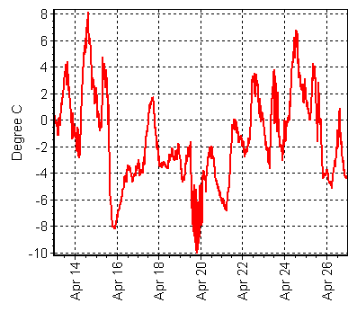
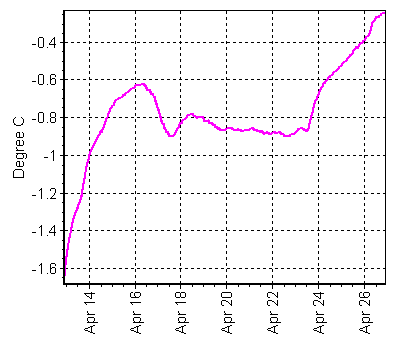
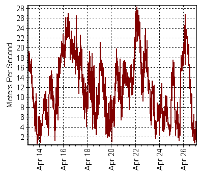
REAL-TIME CLIMATE DATA FROM THE SADDLE

WARNING: These data are raw and have not been quality checked.

For quality-controlled climate data, see here

Air Temperature

Soil Temperature

Maximum Wind Speed

Niwot Ridge Flora

Niwot Ridge has a variety of vegetation communities. Lodgepole pine and aspen stands are found on the lower east and south-facing slopes. Lodgepole pine is replaced by subalpine spruce-fir forests at higher elevations. Limber pines occur in rocky terrain throughout forested areas. In the transition zone between the closed subalpine forest and alpine tundra, meadows are interspersed with islands of stunted coniferous trees and taller patch forest. Above the treeline, the alpine tundra is made up primarily of herbaceous plant communities. The highest, most rugged parts of the ridge are unvegetated scree.

Niwot Ridge Fauna

Animal life inhabiting Niwot Ridge ranges from arthropods to birds and mammals. A variety of bird species utilize the habitats within the LTER ranging from year-round residents like the white-tailed ptarmigan (Lagopus leucura), to more seasonal summer residents like the American pipet (Anthus rubescens), horned lark (Eremophila alpestris), black-capped chickadees (Poecile atricapillus) and white-crowned sparrow (Zonotrichia leucophrys). Of the 31 species of mammals observed on the Ridge, approximately 20 are herbivores, and of these, 12 are small herbivores, ranging in size from mice and voles to marmots. The large herbivorous mammals found at Niwot Ridge include elk (Cervus canadensis), moose (Alces alces), and mule deer (Odocoileus hemionus). Omnivorous and carnivorous species include the American marten (Martes americana), mountain lion (Felis concolor), bobcat (Felis rufus), and black bear (Ursus americanus). The snowshoe hare (Lepus americanus) and porcupine (Erithizon dorsatum) are transient species. Aquatic environments are most commonly populated with a variety of zooplankton, macro-invertebrates, some species of trout.

The Tundra Cam is down. We apologize for the inconvenience and appreciate your patience as we work to get it back online. We will also post updates from NEON regarding their mid-tower phenocam when we have them.

View the Ridge Now

North-facing phenocam at the NEON tower located in the tundra at Niwot Ridge. Images courtesy of the National Ecological Observatory Network and the Phenocam Network.

Phenocam at the NEON tower located in the tundra at Niwot Ridge. Snow stakes visible in the foreground. Images courtesy of the National Ecological Observatory Network and the Phenocam Network.

Phenocam at the Niwot Ridge Ameriflux Site (US-NR1) in the subalpine forest. Images courtesy of Peter Blanken, Sean Burns, and the Phenocam Network.

Phenocam at the Niwot Ridge Ameriflux Site (US-NR1) in the subalpine forest. Images courtesy of Peter Blanken, Sean Burns, and the Phenocam Network.